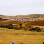
The impetus for this entire trip was finally reached. We rolled into Custer State Park and took up residence in one of their campgrounds, attractive and airy and overlooking Sylvan Lake. We’d made these reservations back in February, and it wasn’t too much longer before they were completely booked. First order of business was to make contact with friends Keith and Cheri Begley. They were our next door neighbors in Tucson in 2011-12. We visited them in Missouri at their home and toured Kansas City with them. We had independently decided to take in the Bison Roundup, so they were 6 miles down the road at the main facility.
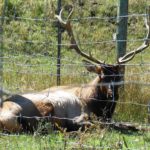
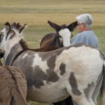
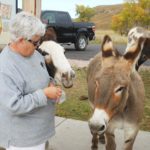
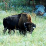
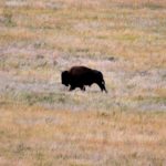
History surrounded us, including Mount Rushmore and the Crazy Horse Monument. But we’d been-there-done-that quite thoroughly in 2010. So during the few days before the big event, we communed with the Park and friends — both two legged and four legged. The bison shown below was in our campground before we arrived, and we met him up close and personal about a mile down the road. As usual, I didn’t trust their docile appearance and stood near an open car door while chatting with him and snapping his picture. The antelopes were also in the campground, and the donkeys on the Loop Road nuzzled us, begging for the carrots Dot brought.
-
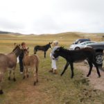
- Friends along the Loop Road
-
- Wondering what she brought for them.
-
- Reaping their rewards.
-
- Posing and Munching
-
- Looking for more fans
-
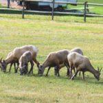
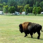
- More wildlife in the community
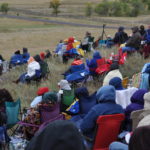
We didn’t believe the rangers at first when they said we should be in line at one of the venues by 5:30 AM on Friday. The viewing areas and corrals were at the bottom of the Loop Road, but you had to choose one side or the other because the road was blockaded at the herd’s crossing. The parking lots opened at 6:15 and closed at 9. By the time we got to the north gate, there were about fifty cars ahead of us. I brought my laptop and alternatively did crossword puzzles and dozed. It took us until about 7:00 to get settled at a parking spot, and it was way up top. We were to regret that later!
Summer weather was nowhere to be found. At that hour, the temperature was in the high 30’s. We dressed for it; this was to be the only day in 2013 that I wore socks. And it never really warmed up. We staked out a place with our chairs, and others crowded in with the morning light. Then came an interminable waiting period; it was not until 11:00 that the drive was due and it actually came later than that.
-
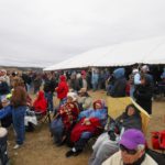
- Breakfast and Hot Coffee were available
-
- In good but cold company
-
- The crowd on the other side of Loop Road
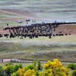
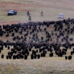
But it was well worth the wait. The first action came high on the hills above the crowd at the south viewing site. First it was one, then a couple, then a small cluster, then a cowboy on horseback and another in a four wheel drive vehicle. On they down the hills, widely spread out and then later gelling into a huge mass that at times was amoeba-like as the drovers worked to funnel them toward the corral. The herd of over 1,000 circled around past us, heading toward the narrow entrance to the corral
-
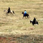
- The Foreguard
-
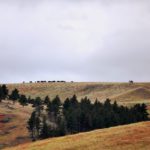
- First over the hill
-
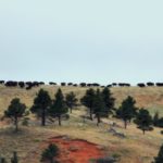
- More on the way
-
- What we’ve been waiting for!
-
- Down the hill and across the road
-
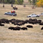
- Milling around in the lower field in front of us
-
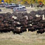
- Bunching up in the slim corral entrance
-
- One dude changed his mind — and they let him go!
-
- In the corral for examinations
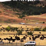
.The purpose of the Roundup is to check on the health of the stock, vaccinate and tag the new herd members, and cull out a portion of the herd for sale to other grazing locations and to food processors. The State Park must constantly keep the size of the herd in check so that ample food is available to support them. The cull is typically about 200 beasts. We thought about claiming one as a pet, but our RV life stopped us. Getting out of the parking lot was a 90 minute proposition. Fortunately, most of the time put us close to the corral where we could watch the bison graze.
Saturday brought on a festival in the Park with food and vendors galore near the headquarters. We explored it, though Dot and I, at least, would not partake of bison burgers. That evening, we treated Keith and Cherie and four pals of theirs to a spaghetti feast at our trailer. And before leaving, we got a bonus: Keith and Cheri told us they’d be trying out our campground in Florida for the 2014-2015 winter season, instead of going back again to Tucson.
Sunday morning brought a brief stop at the “dump station” and travel eastward across South Dakota, aiming for Sioux Falls with a one-night “meaningless” stop in between!