From Crater Lake to the Grand Canyon to White Sands to mighty Glacier, we never get tired of the geological wonders of our Nation. Moab, of course, was no exception.
Founded as a Colorado River crossing and trading post, the city was incorporated in 1902 and gained its early traction from the discovery of uranium, vanadium, potash and manganese –and later oil and natural gas. In the fifties, it was designated the Uranium Capitol of the World, but the end of the Cold War quickly diminished its importance. Today, it’s in its fifth year as a DOE cleanup site.
Moab is a tiny city with a big drawing card – two of them, in fact. Barely 3 miles in area and with a full time population of under 6,000, its two National Parks draw thousands even millions — from everywhere and for many reasons. Both viewing and recreational opportunities abound. The tourist industry was triggered in large part by Hollywood’s use of the area as a stage, most notably for John Ford’s Stagecoach.
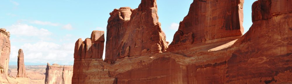
Arches National Park covers about 80,000 acres. Its prominence is due in large part to its first superintendent, Bates Wilson, who served from 1949 until 1972. During his tenure, the park size doubled; roads, a campground and visitors center were built; and the National Park designation was bestowed. He was also influential in the development of its larger sister, Canyonlands. Its significant features are defined by its name; arches and national bridges abound. They are not alone, however, in the diversity of formations, as you’ll see below.
Canyonlands National Park is over four times the size of Arches, but it has fewer than half the visitors. There are two distinct regions within the Park, Island in the Sky and Needles.
Island in the Sky is a mesa that rests atop cliffs of sandstone, a thousand feet above the surrounding landscape. It’s closer to Moab and attracts more visitors. The driving route through it totals 33 miles, and you encounter numerous major attractions, including Upheaval Canyon and Dome, Mesa Arch, Grand View Point and White Rim, overlooking vast and deep canyons. While the Colorado River skirts Arches, it streams through Canyonlands and, in fact, joins the Green River within its borders. Thus, in addition to the recreational aspects, water recreation is a drawing card. Views of the Green River above the confluence are found at the Green River and Grand View Overlooks.
The drive to Needles, however, is 45 miles south and then 30 miles east from Moab. While there is a paved road going in that visits half a dozen landscapes, one needs a 4WD vehicle and/or a sound back and set of hiking legs to visit the majority of its splendor. Having neither facility, we missed the majority of its canyons. But the views we did get to see were worth the drive down. Our biggest regret was not getting close enough to the Green/Colorado confluence and the rapids below it.
In the southwest section of the park, there’s another section called The Maze. On its list of the most dangerous hikes in the country, Backpacker Magazine places it at the top. It has virtually no trails, no water and no shade. It’s claimed no lives, but that’s the result of intimidation that keeps all but the most experienced out of it! It’s also a four wheeler’s attraction, but with similar precautions. Nothing to try without adequate skills, preparation, maps and a GPS.
Between the city limits and the lower tip of Arches lies an additional treat, however: Rte 279. This highway is paved for 18 miles, after which it becomes desolate and accessible only by high clearance off-road vehicles. It runs eventually into the eastern side of Island in the Sky. But there are numerous tasty treats along the paved portion. First, it quickly meets and parallels the Colorado River. Second, it travels through high bluffs that are attractive to climbers. They’re decorated by its forebears; petroglyphs from both the Archaic and Fremont periods are in evidence, sometimes both on the same panels. One next arrives at the Poison Spider Mesa, home to genuine dinosaur tracks. Large tracks left by a Therapod — in sand petrified to stone — are visible from a viewing platform. Tracks from at least ten others are visible along the Poison Spider Trail. While these heirlooms are unprotected, explorers are urged to leave them undisturbed and perform no rubbings.
Further along, the railroad right of way is visible, and, much to our delight, a train appeared from nowhere, passed close to us and continued on its journey. At the end of the paved section stood the Imperial Potash Company, at which the train stopped but transferred no cargo. This is one of three plants owned by the company, and it is sitting on a basin that is estimated to contain 2 billion tons of its final product (potassium chloride), used primarily in fertilizer.
Rte 279 offers stunning formations, like the rest of the area. One of particular mention is the Jug Handle, shown below. Numerous trails through the area are available and accessible to the more fit.
As we returned to our campground, we passed the entrance to UMTRA, the Department of Energy’s cleanup project. The contractor, Energy Solutions, has removed in excess of 6 million tons of tailings, shipping them to their disposal site in Crescent City, Utah. Shipments to date represent about a third of the entire project, scheduled for completion in 2025. Utah’s congressional delegation is seeking funds to double the rail shipments and finish by 2019.
Our campground, which was combined with a large horse boarding/training facility, was pretty barren, but like Argo, it did have a lovely view of the surrounding hills. Moab gave us all we hoped for, and more. And Bryce remains on our bucket list.