Glendive Proved How Little We Know — July 26-29, 2013

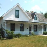
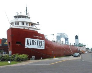
The tentacles of the Oil Boom in Williston reach far and wide.  Minot, 100 miles east, was flooded with workers, and the same was true on the other side of the enterprise in Northeastern Montana.  We wound up finding a campground vacancy in Glendive, MT, about 50 miles southwest of Williston.

Our site was nothing to write home about, but we found plenty to interest us in the Glendive C-of-C’s 92 page tourist and relocation guide. Glendive is the eastern end of the Montana Dinosaur Trail, a chain of 14 museums in 12 communities primarily across the northern reaches of the state.  Glendive sports two locations:  a downtown museum and Makoshika State Park, dubbed the “Badlands of Eastern Montana.”  

the burys

Hell Creek Music’s Steve and Christie Bury

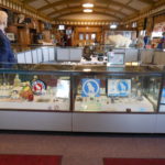
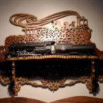
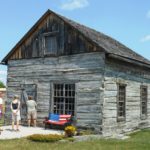
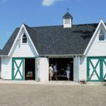
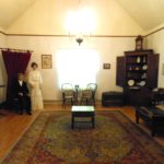
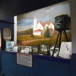
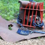
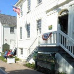
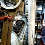
First, the museum.  Steve and Christie Bury, Seattle expatriates, moved with their daughters Chantell and Courtney and $300 to Glendive a decade ago and opened up a music shop, Hell Creek Music, in a century-old downtown building. Walk in and you are surrounded with dozens of instruments and accessories covering every inch of the walls and counters.  If you walk half way down the store and glance right through the archway, you’ll find that a wall divides the space down the middle, and the view on the other side is considerably less contemporary. (Picture at left from the Billings Gazette)

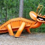
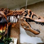
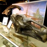
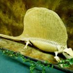
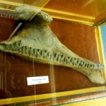
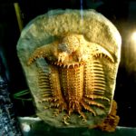
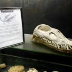
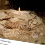
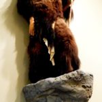
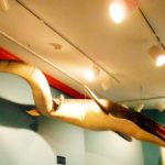
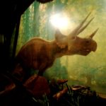
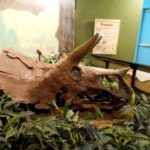
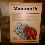
Now it’s Hell Creek Music & More.  Half the space is the Makoshika Dinosaur Museum.  Steve and Christie’s other life is the preservation of artifacts from three ages of the area — Triassic, Jurassic and Cretaceous.  It’s an extensive collection of sculptures, replicas and real fossils, enough to keep you fascinated for a long time.  T-Rex dominates the scene as you enter.

Talented musicians, Chantell and Courtney have flown the coop and are now a popular touring duo out west.  Performing in many well-known hot spots on the coast, they’re known as H3LLOMYNAME IS.

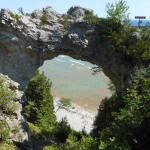
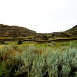
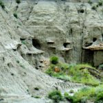
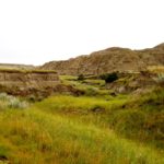
Less than two miles beyond our site, Makoshika State Park is the largest in Montana.  It is at the upper end of the Cedar Creek Anticline, a 30 x 150 mile uplifting in the earth that is described as resembling a ripple in a blanket.  The Anticline runs from there down into the northwestern corner of South Dakota.   You may not be surprised to learn that Makoshika is Lakota for . . . bad land!

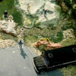
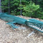
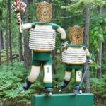
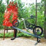
The Park and Anticlime are contained within the Hell Creek Formation, a layer of rock deposited at the end of the dinosaur age that runs from northern Colorado through eastern Wyoming and western Dakotas in an arc covering over half of Montana.  The Park, therefore, is a treasure trove of both geology and paleontology.   Erosion creates hillocks, ledges, mushroom columns and large flats, topped in places with sub-tropical grasses and trees.  Beneath the surface, more than 10 species of dinosaurs have been found, as well as an archaeological richness of many species.  The Park’s Visitors Center offers additional exhibits.


BNSF (2)

Make-ups day and night!

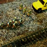
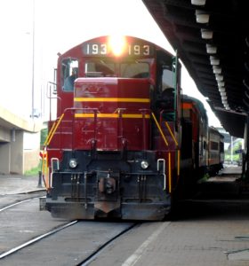
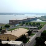
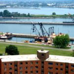
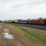
Over the years, we’ve found a strong correlation between the location of campgrounds and the presence of railroading, especially its sounds.  Glendive took that one step further.  About 200 yards away, the lower end of a six track make-up yard was active 24 hours a day.  Trains would come in from both directions and depart after being restructured.  The white noise was the idling diesel engines, and it was supplemented by the slams of couplers and the shouts of the crews.  To us, it was not only non-disturbing; it was a source of entertainment as we speculated on how many cars, how many engines, time of departure and direction.  Simple pleasures!

We had given short shrift to eastern Montana during our three year Journey and were making up for it now.  Read on!

Renewing our Lewis and Clark Connection

By this time, we realized that a stop in Williston proper would amount to nothing but chaos.  The entire area had been consumed by the Oil Boom and its attendant problems.  Not only would we have never found a site to stay in, there were already huge buildings that collectively held the RVs of hundreds of workers who’ve flocked to the area.

But the city wasn’t our real goal anyway.  Twenty-two miles to the southwest, just before crossing into Montana, lies the Confluence of the Missouri and Yellowstone Rivers.  The Missouri continues west from there — the route Lewis & Clark took on their way to the Pacific.  On the return route, however, the two captains split up the party at Lolo, Montana.  Lewis and a few others headed north to explore the Marias River and learn more about the Blackfoot tribe.  Clark, Sacacawea and the others followed the course of the Yellowstone.  They planned to meet a month later at this Confluence.

Lewis and his party had the most trouble, including an unfriendly encounter in which the Expedition took he lives to two thieving Blackfoot braves — the only fatal encounter on the entire trek.  Clark and company were also hassled by the Crows, who stole 28 of their horses, but no bloodshed occurred.  The groups finally reunited as planned, but not without many anxious moments.

We expected the Confluence to be more of an L&C shrine than it was.  While the Interpretative Center certainly acknowledges the visit of the Corps, considerable other events of historic proportions occurred there as well, such as the building and manning of trading posts and military forts in the region.

We stayed for an hour, crossed it off our bucket list, and moved onward to Glendive, Montana for the next few nights.

Minot, ND — July 23-25, 2013

Our Rte. 2 journey next led us to Minot.  That was good and bad.  The northwest quadrant of ND has become the recipient of the Bakken Boom, an oil discovery in 2006 that is still pumping strongly today.  It has given the state the lowest unemployment rate in the nation and created a billion dollar surplus in the state treasury.  All very good — except to those of us who are not looking for a job or a place to live.  The core of this discovery (not to be confused with Lewis and Clark’s Corps of Discovery!) is in Williston.  We were interested in visiting Williston while on The Journey because it was an area through which Lewis & Clark passed not long after their first winter in Mandan.   Today, Minot —  halfway across the state and still 125 miles east of Williston — was inundated with workers and commercial resources.  Our campground was the pits, hastily expanded to accommodate the families who’d come to seek their fortune.  There was a serious robbery from the rig next to ours and police intrigue on more than one occasion.  Our neighbors ran dump trucks that left at the break of dawn for twelve hours of runs through the area.

So we hunkered down and tried to slide into the community that existed before the maelstrom.  Several attractions got our nod.

Minot evolved when Jame J. Hill’s Great Northern Railroad stopped there in the winter of 1886 because of the difficulty of spanning the Gassman Coulee with a trestle.   The city was incorporated a year later.  A typical boom town, it took a great leap forward when the Pentagon built the Minot Air Force Base in the fifties, later to become the Strategic Air Command Bomber and Minuteman Missile Base.

Scandinavian Ctr (1)

Entrance map

Scandinavian immigration to the area began as early as the 1870’s and continued strongly for many years.  Norwegians are the largest segment, followed by Swedes and Danes.   It’s no surprise, therefore, that the downtown landscape is visually and spiritually enhanced by the Scandinavian Heritage Park.   At the entrance, the Plaza Scandinavia features a 60 foot inlaid map of the five major countries that contribute new American citizens.  From it, paths lead to many fantastic exhibits, including the 30 foot high Dala Horse, the 60 foot high replica of the Gol Stave Church, and the Sondre Norheim Eternal Flame Monument.  In addition to Norheim, the father of modern skiing, celebrity statues include Leif Eriksson and Hans Christian Andersen.  One path led to a museum of history and curious artifacts.

Not surprisingly, we sought out the local railroad museum.  It took a couple of trips around the block to find it, and, when we did, the door was locked.  Walking back to our truck, we looked in the back door and found a group of people around a document-laden table.  They let us in!

Known as the Old Soo Line Depot Transportation Museum and Western History Research Center, the latter part appears to be the more important.  They are only open when staff is working, and they ask for a call-ahead.  They let us wander through the handsome building at will, but when I glanced at a stack of non-public documents that were sitting on one of the exhibits, they quickly swept them up!  But the displays were informative, and here’s a brief look.

I ventured north to visit the Dakota Territory Air Museum, near Minot Air Force Base.  Opened in 1986, it is fulfilling a dream of documenting both the civilian and military legacy of aviation in the region.  It displays almost three dozen of the former and about ten of the latter, and it continues to receive new exhibits.  An F-15 that flew out of the Base for almost 30 years is on the way this fall; it was part of a defensive squadron known as the Spittin Kittens!

The non-hardware part of the museum is filled with a conglomeration of posters, photographs, models, feature and first-person stories, and reams of documentation on the influence of aviation there and throughout the world – so much that the effort to organize and display all the stuff is a perpetual challenge (and still requiring a lot of work!).

One fabulous attraction remained.  A separate hangar reserves space each year for the arrival of the Warbirds of the Texas Flying Legends Museum.   Based in Houston, the Flying Legends is a collection of vintage aircraft that travels the nation annually as air show participants.  The fleet flies to Minot each May for a two month stay, then moves on to Wiscasset, Maine before returning back to Texas for the winter.   About to leave, they were being serviced for the next leg while we were there.  In fact, The Last Samurai, a Japanese Zero, was out at the shop, so I borrowed the picture of her below from the Museum’s website.

We were glad to leave Minot and not excited about having to drive through Williston.  But Montana — our favorite state — waited on the other side!

Grand Forks, North Dakota — July 18-21, 2013

Previous journeys have put us on east-west routes across lower sections of North Dakota.  Since we were up near the top of the Union anyway, we decided to try the northernmost path, Rte 2.  We took it out of Duluth and stopped first in Grand Forks, ND.  Actually we didn’t!  We stopped just short at East Grand Forks, Minnesota, just across the Red River.  There, the Red River State Recreation Area provided full hookup pull-thru sites spread widely through the park.  Not cheap, and with a daily use fee on top of it.  But spacious, comfortable and efficient.

We spent most of our time in Grand Forks ND itself, but we took in a fascinating experience in East: the Northern Lights Railroad Museum.  Originally started as a model railroading club in the 1980’s, it has grown to interpret the history of railroading in the Northern Great Plains.  It’s housed in a replica train depot built by volunteers after the 1997 flood (much more on that later) and has been expanded since.  Clearly a work in progress, it houses two model railroads, one in HO gauge depicting the Great Plains and the other in N gauge, depicting the Mid-West logging industry. Some of the tiny HO details are outstanding, such as a boy scout troop and a prison work gang, both shown below.

The Red River, a.k.a. the Red River of the North, forms almost the entire border between Minnesota and North Dakota.  Its source is at Wahpeton, ND, approximately 50 miles SSE of Fargo, and it passes Fargo and Grand Forks on its way a little over 300 miles to Lake Winnipeg, Manitoba, just north of its capitol.  Yes, it’s the river made famous by the song, Red River Valley, which probably originated in Manitoba around 1870 and has many different titles and sets of lyrics!

The “RRN” is best known for flooding.  You have listened more than once to The Weather Channel’s intimate tracking of its flood stages, which began in the paleo era but have caused devastation more recently in 1997, 2009 and 2011.  Of those three, the first was the worst in this area, in large part because the major metropolises along its route were better prepared to fight the onslaught after the 1997 devastation.

In 1997, water spread up to 3 miles on either side of its course, causing 100% of E. Grand Forks and 75% of Grand Forks to be evacuated for weeks.  After the wipe-out, Grand Forks built a series of retractable flood walls.  All of the homes on Riverside Drive and most of those on picturesque Lewis Boulevard were demolished or relocated to make room for the protective system.  Careful attention to detail allowed the Riverside Historic District to be placed on the National Register in 2007.  Numerous architectures, including Queen Anne, Bungalow, Mechanic’s Cottage, Tudor, Dutch Colonial and American Craftsman are represented in Riverside.  Numerous turn of the century commercial, consumer and government structures form another impressive tour.

The Grand Forks project worked.  2009 and 2011 produced the third and fourth highest floods in the city’s history, with no significant damage in the area.  Both of those wreaked more havoc north, in Fargo and in Manitoba.

The Grand Forks County Historical Society was established in 1970.  Today, it operates a campus-style museum that highlights much of the good that North Dakota represents.  It began through the auspices of the Campbell family.  Thomas senior and his wife homesteaded near the River in 1875.  They built a log cabin and sired a son, Thomas junior, in 1882.  The cabin was incorporated into their Dutch Colonial home.   Junior became “America’s Wheat King” (story below).  The family donated the house, 3 acres of land and a restoration fund to the Historic Society, and in 1971, the opening was dedicated to Junior’s mother, Almira Campbell, representing all pioneer women.

Joining the Myra Museum and the Campbell House, four additional buildings and a bandstand are located on the property:  Log Cabin Post Office, One Room Schoolhouse, Carriage House and Lustron Home.

The foundation of John E. Myra (1857-1939), a successful entrepreneur who was one of the largest landowners in the area at the time of his death, funded the construction of the Myra Museum, designed after the Campbell home.  With no natural heirs, he earmarked the bulk of his estate for charitable purposes, including making over 4,000 acres of land available to local farmers.

Numerous stories of interest are found within the museum.  GF Museum (11)Grand Forks was the home of Cream of Wheat.  The chief miller of a flour mill teetering on bankruptcy after the 1893 crash, devised a way to convert the leavings into the creamy product we know today.  It took less than two years for the product to turn the tables, and today it’s manufactured in Minneapolis.

GF Museum (30)

Campbell House

The aforementioned Thomas Campbell, Jr. (1882-1966), an avid student and athlete, received the first engineering degree granted by U-ND in 1904.  He created the largest privately owned wheat farm in Hardin, MT in 1918, over 95,000 acres.  He seeded 100 square miles of wheat annually.  Campbell showed his patriotism by volunteering in both WW I and II, rising to the rank of Brigadier General and establishing a close friendship with Dwight David Eisenhower.

Coincident with the efforts of Tom Campbell were the pioneering efforts of Gust Hagert (1873-1962).  Hagert emigrated from Sweden at age 16.  In 1906, he married Bertha Sand (1880-1973), a schoolteacher whose family emigrated from Norway.  The Hagerts had seven children.  Thanks to Gust and Bertha and generations of their offspring, the homestead that he began and built into a major enterprise survives today as the Hagert Seed Company.

GF Museum (7)

The Quiet Room

Bertha’s wedding dress had been turned into clothes for the children.  As a gift to their parents on their 50th wedding anniversary, Dorothy and Blanche, their eldest children, had a replica made.  Later, after the deaths of Gust and Bertha, the family created a memorial Quiet Room in the Myra Museum to honor them.  Mannequins of their parents were custom-made in France duplicating their wedding picture pose.  They now entice museum-goers to enjoy a few moments of tranquility in the Quiet Room.

Fred P. Nash journeyed from Vermont to the Dakota Territory to homestead.   Eschewing the farm, he opened a confectionery store and invited his brothers, Willis and Edgar, to join him.  The business went through the usual setbacks until 1889, when a boxcar of peaches was routed by mistake to Grand Forks.  Seizing the day, the brothers mortgaged everything to buy the load and wholesale it throughout the area.  Joined by 14 year old Harry Finch that same year, they eventually parlayed their skills to expand the business, and by the end of WW II, they also owned their own supermarkets.  Nash Finch stock did an IPO in 1983 and today is a multinational corporation on the Fortune 500.   Hey, there’s gold in them there peaches!

Perhaps the most unique of all was the Lustron Home.  In 1947, the Lustron Corp. received a major grant from the federal government to produce a prefabricated home made out of enameled steel.  It was virtually maintenance free, and it could be erected quickly to satisfy the needs of returning GI’s.  Expecting to build 40,000 homes in the first two years, only 3,000 were built, and the company closed its doors in 1950.  The house on the Historical Society property was one of about 20 in the area.  It was flood-ravaged in 1997 but carefully restored and re-erected here.  Between the house, the advertising and the artifacts displayed within, it is truly a déjà vu for those of us in our 7th or 8th decades.  See examples below.

This trip through the County Historical Society’s comprehensive exhibit ended our visit, with total satisfaction.


Duluth — July 11-17, 2013

Train tour

Waterfront

It was our hope, this time as well as the last UP visit, to travel northwest into the rich copper country. But we decided, instead, to maintain our course, and the next stop was Duluth.

But that was a mistake — we spent a week in Duluth and never really connected with the city.  Why we longed to go there, we can’t really recall!  We visited the waterfront, the sight of another freighter-museum.  And we took a tour along the waterfront on a local railroad spur turned into a tourist attraction. The train ride was to and fro for about ten picturesque miles. We rode one way in an open (chilly) car, and we went upstairs into the dome of one of the closed cars for a birds-eye view on the way back.

And we toured Glensheen, a standout attraction.
Chester Arthur Congdon (1853-1916) was a Rochester, NY born lawyer and financier. He graduated from Syracuse U. in 1875 and married a classmate, Clara, six years later. By 1892, he and Clara were in Duluth, where Chester amassed a fortune, primarily in copper and iron mining. He was a sensitive man of quiet philanthropy, but he also splurged over $850K on an estate overlooking the city. It was built between 1905 and 1908, and it has been identified as a “melding of late Victorian, Arts and Crafts and Art Noveau.” The 39 room mansion sits on 7.6 acres of Lakefront property.
One of our very favorite mansion visits is Copshaholm, the South Bend mansion of the Joseph Oliver family. Built in 1896, it remained in family hands until it became a museum with original family content. Glensheen shares the same honor; it served the family for its entire life until donated to the University of Minnesota in 1968. It even includes Chester’s top hat and some of Clara’s handwritten letters among its artifacts. Clara outlived her husband by 34 years; she was still a resident when she died in 1950 at 94.
Elisabeth Congdon, sixth of Charles and Clara’s seven progeny and last surviving member of her generation, retained residency in the home until 1977, when she and her nurse were murdered by Roger Caldwell, the second husband of her adopted daughter, Marjorie. Roger’s double-life sentence was overturned, but he confessed soon thereafter and committed suicide. Marjorie was found innocent of co-conspiracy, but she went on to a life of crime.

First contact with the estate is the Gardener’s Cottage (below left), occupied by the same family for 83 years. It’s the only building on the estate that was ever modified. It housed George Wyness, hired in 1921 to be the family gardener, and the cottage was later enlarged for his growing family. His son, Bob, took over the clippers for his dad and was the last person to live on the property, departing in 2004 with his wife Elsie for a retirement home.

Next, the Carriage House, which now serves as tour-central. One first passes through the stables, then moves on to the vehicle room with numerous carriages and a motor car, perched on an elevator that took it to its upper-floor storage. The yellow-topped is a Studebaker Mountain Wagon, purchased in 1907, a South Bend product that preceded their auto manufacture.

Our trip through the mansion allowed very limited photo opportunities. On the other hand, it treated our eyes to the exquisite trappings that money can bring. Clara had a strong hand in the selection of interior treatments and both Congdons had a fondness for landscaping. It was truly worth the stop.

Fulfilling our UP Promise: July 6-10, 2013

We visited Marquette in 2010, near the western end of Michigan’s Upper Peninsula, which is like a “roof” over the state. We loved the city and conveyed many stories of its beauty and history in our e-book, The Journey.  And we heard so much about the UP that we vowed to visit more of it, especially the eastern end.

This was our chance.  Heading north again on Rte. 75 across the Mackinac Bridge dropped us in St. Ignace, and another 50 miles put us in Sault Ste. Marie – as far as you can go without crossing the Canadian border.  (Incidentally, the other end of Rte. 75 is just north of Miami!)

Sault Ste. Marie translates to “Rapids of St. Mary.”  They bridge the gap between Lake Superior and Lake Huron.  The “Soo” Locks first tamed the rapids in 1855.  Today, there are four locks available for ships of all sizes maintained by the U.S. Amy Corp of Engineers:   Poe (1896; rebuilt 1968), Davis (1914), Sabin (1919) and MacArthur (1943). Davis and Sabin are supposed to be replaced by a super lock; while ground has been broken, the funding is still not appropriated.  There is also a small lock on the Canadian side, opened in 1998, that is used primarily by pleasure craft.  Fun facts:  the locks handle  over 90 million tons of cargo on 11,000 ship passages annually.  A single 1000 foot “Laker” carries the cargo of 60 – 100  train cars or 2,300 large trucks.  The neighboring hydroelectric plant produces over 150 million kwh of electricity each year.

We had lunch at the appropriately named Lockview Restaurant, and we watched a huge Coast Guard buoy tender maneuver itself into the nearest lock.  As we sat there finishing up our sandwiches, it began to disappear.  We chomped quickly and ran across the street to view the sinking as the water flowed out and lowered it to the outbound level.  Regrettably, I had neither camera nor cell phone!

Tower of History (6)

MV Valley Camp Museum

Sault Ste. Marie also provided an opportunity to explore one of the mighty ore ships stem to stern.  The MV Valley Camp (1917) is berthed on the waterfront as a museum representing the fleet that plies the waters of the lakes to this day.  Inside its vast cargo hold and around its decks are numerous exhibits revealing the challenge to take these behemoths to sea.  One can wander from stem to stern.  If you visit the wheelhouse and look aft, the fantail seems to be in the next county.  An informative exhibit is a series of simple charts that show each lake, its position in the chain and the commercial shipping value it brings.  Please enjoy the gallery below that  pictures many features of this self-guided tour.


On one level of the poop deck is a memorial dedicated to the Edmund Fitzgerald, whose loss with all hands in 1972 is retained for posterity by Gordon Lightfoot’s  mournful ballad.  The complete lyrics are part of the exhibit.  More poignant, however, is the battered lifeboat that may have given brief hope to some of the crew.  As a lifelong sailor, I am reminded, with tears in my eyes, of the Navy Hymn:  Eternal Father, strong to save / Whose arm hath bound the restless wave / Who bidd’st the mighty ocean deep / Its own appointed limits keep / Oh, hear us when we cry to Thee / For those in peril on the sea.

Tower of History

Tower of History

A sister exhibit to the MV Valley Camp is the Tower of History.  A 210 foot structure, it was originally built by the Catholic Church to herald the early missionaries in the area.  Today, it provides historical extracts of the region’s religious and secular history.  I found it even more fascinating as the source of a bird’s eye view of the entire downtown and harbor area.  The results are below.  It took me a long time to find out what the long building along the waterfront is:  The Cloverland Cooperative Hydroelectric Plant!

After Sault Ste. Marie, we trekked westward across the UP.  We did stop in Marquette again, to refresh our minds of the  beautiful Lake Superior. In fact we found one new – and one renewed – attraction to visit.

"Nugget" in Presque Isle Park

“Nugget” in Presque Isle Park

Our friend Worsley in Grand Rapids declared that the largest copper nugget in the world was not to be missed.  We drove back to Presque Isle Park, a venue with which we were very familiar, and found it — a slab of “glacial float” copper, discovered in the Keweenaw Peninsula in 1998 and moved to the park two months after our earlier visit.  It measures 15 x 13 feet and weighs 28 tons.  Float copper or drift copper is literally transported by glacial movements.

We were in town in 2010 on the very last days of the existing Marquette Regional History Center.  Our return allowed us a trip through the new facility.  Night vs. day — it was a major wow factor.

Junk Art (1)

The entrance sign.

How we missed Lakenenland last time around, we can’t figure.  It has been open since at least 2007, about 15 miles outside of Marquette.  Tom Lakenen is an ironworker-turned-artist who has created a drive-through park of immense proportions.  He built the 37 acre park and its 80 sculptures to “have something to do during layoffs after I stopped drinking.”   Harassed by the local jurisdiction, a town called Chocolay, he continues to try to provide something for everyone.  In addition to his art, he’s built perch-filled ponds for young anglers, a rest stop on a snow machine trail though his property, and a bandstand for anyone to use and enjoy.  The path through his art  is not a route one can take casually; it’s important to walk it or drive it twice with many stops of contemplation on the second pass.  Like the Hudson car pictures in Shipsewana, I will limit my pictures below – with difficulty.  My artistic readers, I hope, will demand more!

We consider ourselves even more Yoopers than ever.

Mackinac Island — and a Reunion: June 27-July 5, 2013

You say tomato and I say tomahto.  You say potato and I say potahto.

You say Mackinac and I say Mackinaw . . .

The real skinny:  The French spelled it with “ac” on the end but pronounced it “aw.”  The British heard it pronounced “aw” so they spelled it that way. Whichever way it is spelled, it is always pronounced “aw.”

We were already due south of it at the Heartland Rally, and our home club, the Friendly Maryland Travelers, were heading there for a Rally. Longtime members, we hadn’t joined them for eons because of our cross-country adventures, so it was nice to hook up again. We all stayed in the Mackinaw City Park in sight of Mackinac Island and not far from the Mackinac Bridge across the straits between Lakes Huron and Michigan. It’s a large, naturally-designed, well-maintained park with many sites on the Huron shore.  We did group meals, side trips down town, a day-long July 4th party and, of course, a trip over to Mackinac Island itself. We took a jet boat over.  There are no cars allowed on the Island except an ambulance.  Some of our folks were drawn to a three hour long horse-drawn tourist cart adventure, while others brought their bikes.  As we went past the Grand Hotel, biggest and fanciest on the island, we learned they charged gawkers $10 to enter the grounds and look around!

Back on the mainland, we toured the Icebreaker Mackinaw Marine Museum.  The ship was commissioned in 1944 primarily to keep shipping lanes open for the transport of raw materials during WW II.  She is 290 feet long with three propellers – two aft and one forward – driven by six monster diesel engines.  She served until 2006, when she berthed for good in her namesake port and gave way to a new Mackinaw, the slightly smaller WLBB-30.  The docent in the engine room when we took our tour was very well versed, and she handled my curiosity thoroughly.

Another highlight was a spin along the waterfront.  Old Mackinac Point Lighthouse is adjacent to Fort Michilimackinac, where a statue tells the story of one of the earliest English inhabitants.  After the British gained control of Canada and the Great Lakes in 1760, 22 year old Alexander Henry (1739-1834) made his way down from Montreal to explore the fur trading opportunities.  Others followed and continued to use the Fort, abandoned by the French, as a trading post.  A year later, the Ojibwe entered the fort, killed all the British and held it for a year.  Alexander, however was spared by Chief Wawatam, who adopted him as a son.  A year later, when the Ojibwe were repulsed, Alexander was granted a monopoly on fur trading on Lake Superior.  After 11 active years, he returned to Montreal and became a merchant.  Among his plaudits is the fact that he introduced John Jacob Astor to the Canadian fur trade.

Mackinac Bridge

Mackinac Bridge

And then we trekked the long span to the Upper Peninsula.